Har-ki-Doon Trek: 5 Nights/ 6 days
Places Covered: Dehradun – Sankri – Osla – Har ki Dun – Osla – Sankri – Dehradun
Upcoming Treks:
June
September
October
November
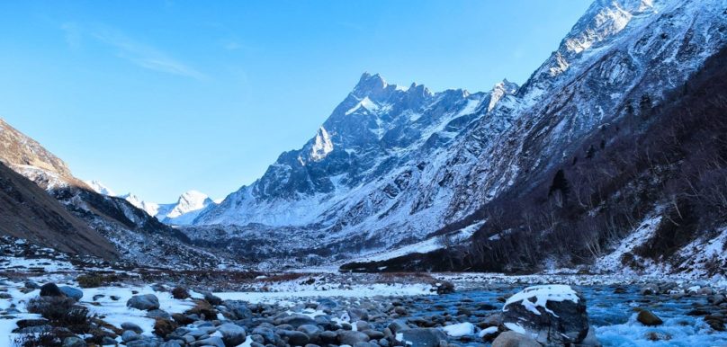
Itinerary Day 1: Dehradun to Sankri - 8 h drive (187 km) We start early from Dehradun and drive through the villages of Damta, Purola, Mori, Netwar and reach Sankri by evening. Soon we start following the river Yamuna upstream. The river Kamal Ganga merges with Yamuna near Naugaon and will accompany us till Purola. Purola is the last big settlement on the way with a large market. The drive after Purola is through a beautiful forest of pine trees. From near the village of Mori, the river Tons flows beside us till about Netwar. The drop in temperature can be felt from here. We officialy enter Govind Pashu Vihar Wildlife Sanctuary after we cross a check post at Netwar. It can be considered the southern gateway to the sanctuary as most of the treks across the region are accessed from here onwards. Close to here the rivers of Rupin and Supin merge to form Tons, which is the largest tributary of Yamuna and in fact larger than Yamuna itself, in terms of volume of flow. The peak of Kedarkantha can be seen from various points along the way here. We reach Sankri by early evening. It is a small village with a central market lined with a few shops. The village has numerous apple orchards. One can see the Swargarohini peak from here on a clear day. We rest at night in a guest house or in camps. Day 2: Sankri to Osla (2,700 m) - 1 h drive + 5-6 h trek (14 km) Post breakfast we are transported from Sankri to Taluka. The drive is a bit bumpy. The trek commences from Taluka on a stony path. The fragrance of cedar trees can be felt around Taluka. Sometimes during winters, or especially during periods with rather heavy spells of rain, the road to Taluka may be too dangerous for vehicles, as streams run across the road and thus one may be required to walk a stretch of around 8 km up to Taluka, albeit it is only ocassional. After Taluka we are met with the river Supin gushing through rapids beside us, under the shade of walnut, pine and other trees, the walk is quite pleasant. In autumn we can often find walnuts lying around. One must avoid touching the vegetation on the sides for there are Stinging Nettle plants here locally known as 'Bichhu ghas' or 'scorpion grass'. Often the passing villagers greet us on the way. High up above on the true left, we get to see the village of Datmer. It is lined by series of step farms. The path crosses over a few streams which merge with Supin. After a few hours of walk the village of Gangad can be seen towards the left, across the river. We can find edible fruits of seabuckthorn in this area. We continue our trek and soon, the quaint village of Osla unfolds itself. One comes across a small hut with a water mill on the right of the trail. Water mills use the power of streams to grind grains. After less than an hour, we reach Seema which is a tiny settlement opposite to the river from Osla. We set camp here or stay in a hut with a local family in the village. Day 3: Osla to Har-ki-Dun (3,510 m) - 4-5 h (10 km) The area surrounding Osla is full of terraced farms. The colors of the farms are different in every season. The red farms of Cholai (Amaranth) look amazing and can be seen from late monsoon. From Osla the trail gradually rises higher. We come across a temple some distance below the trail. We pass through bushes of flowers like orchids, fleece flowers and sunflowers. The ascending path climbs high above the confluence of Supin river and the river from Ruinsara valley. Walking high above this confluence, we get a view of the snow-clad peaks of Ruinsara valley including Black Peak. After traversing higher up along the true right of the river, we camp at a very panoramic spot in Har ki Dun , located at the junction of two valleys: one originating from Jaundhar glacier and the other from beyond Hata glacier. Higher up towards the North we can spot the Forest Rest House, while the wood crafted GMVN guest house lies further up in the distance. The minor ridge to our right, lined with a few scattered himalayan birch trees (Bhojpatra) that seperate us from the massive Har Ki Dun valley that goes up all the way to the base of Swargarohini Peak. The paper like bark of these trees was used in ancient times to write scriptures in Sanskrit. Day 4: Explore Har ki Dun We can choose to relax and soak in the environment or we have several trails as options. The vast open meadows following the course of the Supin river can be explored. Further ahead of the meadows one can walk among the forests of Bhojpatra trees (Himalayan birch) or get a closer glimpse of the Jaundhar glacier and Swargarohini peak, for which we will have to head updwards the Har Ki Dun valley, towards the Swargaroini peak in the eastern direction. It is also possible to walk till the base of Swargarohini peak. Being a long journey for the day, it would require to carry along sufficient food supplies, water and some cloths to aid against an abrupt weather change. The first rays of the sun can be seen falling atop the Swargarohini peak. One can visit the Marinda Tal, in the north, just 2-3 km away from Har ki Dun. The trail is gradually ascending here. It is a small lake formed by a huge boulder obstructing the river which flows down from the base of the Borasu Pass. The little-known valley of Hata can be explored which lies in between the above two valleys in the North East direction. It also has some large meadows and a close view of the Hata glacier and Hata peak. Day 5: Har ki Dun to to Osla - 3-4 h (10 km) The journey back to Osla is an easy walk. We take the very same route which we used to reach to Har Ki Dun. After the initial descent through the forest we trace back our way towards Kalkatidhar, the rather exposed section of the trek. On the route we come across a good view of the trail all the way to Osla and see the valley descend towards Taluka, around the curve of the ridge where the two streams comng from Har Ki Dun and Ruinsara respectively, converge. A little short of this intersection we can get a glimpse of a trail to our left marked by a sight of a bridge down over the stream. This trail goes to join the trail to Ruinsara lake and is rarely taken. After reaching Osla, one can roam about in the village, talk to locals and soak in the Garhwali culture. Again we can either set camp or stay with a local family. Day 6: Osla to Sankri - 4-5 h trek + 1 h drive Early in the morning, we bid farewell to the villagers of Osla and trek till Taluka. The walk is downhill and hence takes lesser time than before. A vehicle from Taluka takes us back to Sankri, where we retire for the day in camps or a guest house. Day 7: Sankri to Dehradun - 8 h drive The trek to Har ki Dun concludes today as we leave Sankri and reach Dehradun by late afternoon.
Temperature: 20°C Max/ 5°C Min - Summers, 10° Max/ -10° Min - Winters
The campsite at Har ki Dun is the coldest among all the camps. The trail receives a lot of sunlight and is pleasant during the day.
April to June
September to December
Possible in other months subject to weather conditions
Maximum Group Size : 12